
|
Yager
Creek Sub Basin |
Yager Creek
The Yager Creek Subdivision consists of 137.5 square miles and 87,975 acres of land. Yager Creek is a significant salmon bearing creek emptying into the main stem Van Duzen River. Our monitoring station is located by the Carlotta Grange Hall just upstream from the bridge at Highway 36 across from the old Pacific Lumber Company Mill site.
Previously an all year round stream, Yager Creek at the bridge at Highway 36 has been going underground in the late summer since October 2001. Prior to this occurrence, old timers remember that Yager last went underground approximately 40 years ago. During the rainy season, Yager Creek can rise up to nine feet bank to bank.
The following are views from the bridge.
Yager Creek October 22, 2001
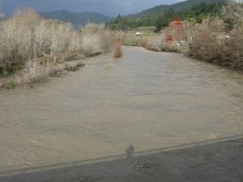
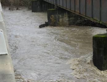
Yager during storm event January 4, 2008 Yager Bank to Bank January 4, 2008
Mr. Jim Rizza, retired science teacher, Jesse Noel, and Paul Trichilo,
project director have been monitoring Yager Creek for the past two years
for turbidity and suspended sediment. Karen Bromley,
Yager Creek is one of the last remaining salmon bearing streams in the Van Duzen River Basin. Each year, fisherman line the shores of the main stem Van Duzen hoping for a catch. The Van Duzen River Basin has been catch and release for the past fifteen years due to a severe decline in salmon population. Yager is very important in that it has surpassed Grizzly Creek as the best remaining tributary for salmon migration in the Van Duzen River Basin.
The Yager drainage carries significant amounts of sediment during storm events. The following information is from our Annual Monitoring Report for the 07 Hydrological year. Because of its size, volume of water, and catchment area, Yager Creek was observed to carry more sediment than any other stream, which was an order of magnitude greater than the second highest, Grizzly Creek (10 million NTU_CFS to 1 million NTU_CFS. The amount of turbid material carried in Yager Creek was surpassed only by the amount recorded for the main stem Van Duzen River at the Weare site. These findings were corroborated by Karen Bromleys research with found that total suspended solids were highest in Yager Creek from measurements taken during storm events from November 2006 to April 2008.
Water quality criteria developed by the Environmental Protection Agency recommends that the maximum weekly average temperature (MWAT) threshold should not exceed 18 degrees C (64.4degreesF) during the summer months for coho salmon and 19 degrees C(66.2 degreesF) for steelhead and rainbow trout (EPA 1986). Further research by Karen Bromley indicate that temperatures in Yager Creek and and the two sites on the Van Duzen River exceeded the recommend MWAT threshold for the entire continuous monitoring period 6/7/07 9/21/07.
For more information on these reports access our annual monitoring report at www.fovd.org
Comments on Van
Duzen River and Yager Creek Sediment TMDL with Recommendations for implementation
Action and Monitoring
Click
here to view in PDF format
Click here to view in Microsoft PowerPoint